Central Maluku Regency
Central Maluku Regency is located at 2o30’ – 7o30’ N and 250o – 132o30’ E covering area about 275,907 Km2. The Regency together with North Maluku, Southeast Maluku and the capital city of Ambon was established under Law 60 Tahun 1958 (L.N. No 111/1958). The regency is boredered by:
In the North: Seram Sea
In the South: Banda Sea
In the West: Western Seram Regency
In the East: Eastern Seram Regency
Source: http://maltengkab.go.id/
The regency consists of 17 districts (Table 1).
Table 1. District (Kecamatan) Area Coverage in Central Maluku Regency
|
District (Kecamatan) |
District capital city |
Area Coverage |
|
(Km2) |
||
|
1. Banda |
Banda Neira |
172 |
|
2. Tehoru |
Tehoru |
248,22 |
|
3. Amahai |
Amahai |
1.619,07 |
|
4. Kota Masohi |
Masohi |
37,3 |
|
5. T, Elpaputih |
Sahulau |
120 |
|
6. TNS |
Waipia |
24,28 |
|
7. Saparua |
Saparua |
176,5 |
|
8. Nusalaut |
Ameth |
32,5 |
|
9. P. Haruku |
Pelauw |
150 |
|
10. Salahutu |
Tulehu |
151,82 |
|
11. Leihitu |
Hila |
147,63 |
|
12. Leihitu Barat |
Larike |
84,47 |
|
13. Seram Utara |
Wahai |
7.173,46 |
|
14. Seram Utara Barat |
Pasanea |
705,48 |
|
15. Seram Utara Timur Kobi |
Kobi |
280,65 |
|
16. Seram Utara Timur Seti |
Kobisonta |
186,19 |
|
17. Teluti |
Laimu |
286 |
|
Total |
|
11,595.57 |
Source: Maluku Tengah Dalam Angka, 2012
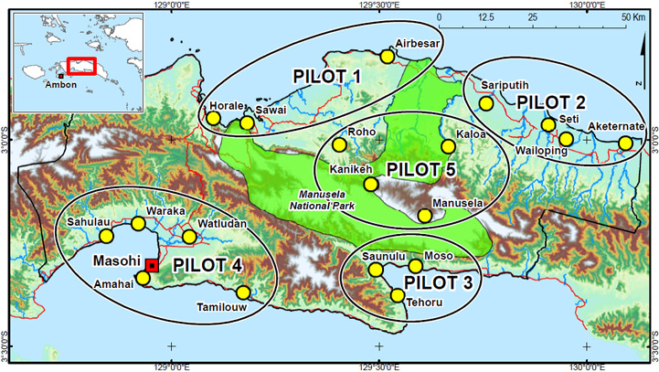
Five “pilot sites” area were chosen for more detailed studies, representing the spectrum of land-use activities and biophysical conditions found in Central Moluccas Regency.
Table 2. The CoLUPSIA’s Pilot Site Areas and their Critical Issues in Central Maluku Regency
|
Pilots |
Location |
Critical Issues |
|
Pilot 1 |
Villages in the northwest part of central Seram Island (Sawai, Horale and Air Besar) |
|
|
Pilot 2 |
Villages in the northeast of Seram Island (Sariputih, Aketernate, Seti and Wailoping) |
|
|
Pilot 3 |
Villages in the south of Seram Island (Tehoru, Saunulu and Moso) |
|
|
Pilot 4 |
Villages in the southwest of central Seram Island and near the urban centre of |
|
|
Pilot 5 |
Very traditional villages in the mountainous areas in the central mountains (Roho, Kanikeh, Manusela and Kaloa) |
|
