
- PMRV
- Background
- Sampling methods
Site Selection procedure
In order to achieve a comprehensive understanding of the feasibility of PMRV, each project site was selected according to three different situations, based on forest characteristics, since it is assumed that the attitude and behavior of people in these areas would be in contrast with each other. The first site, Mamberamo Raya in Papua, was selected to represent an area largely covered by natural forest. Meanwhile, in Kapuas Hulu, forests are being increasingly degraded and Wonosobo, in central Java, represents a mosaic of land uses dominated by agroforestry and cropland, devoid of any natural forests.
In each site, two or three villages were selected for qualitative and quantitative data collection (Table 1). We applied a multivariate clustering analysis to determine which villages were to be chosen involving five dimensions: demography, economic pressure, accessibility, land-use, and land-cover. A clustering analysis was conducted to understand the characteristics of the sites. The process began with a principal component analysis for each category of information, for example information on demography consists of the number of habitants and the density level; local economy is characterized by the existence of public facilities (education and health) and business support (markets, shops, banks), and accessibility consists of the distance from the sub district center, land-transportation, and the presence of a mobile phone signal. A principal component analysis was completed to combine the information of several indicators into one single dimension. Next, the villages were grouped into homogenous clusters followed by a descriptive analysis of each group in order to select the village candidates for the pilot sites.
All the above were based on secondary data (Potensi Desa village potential [PODES 2010], Badan Pusat Statistik – central agency on statistics [BPS 2011]), which, despite a lack of accuracy, gave us an overview of the situation in each province and district. Qualitative and subjective considerations also accommodated information provided by the aforementioned quantitative data by BPS and remote sensing images. We wanted to select sites based on our experience, not only on secondary data, especially in Papua, where we have worked for the last 10 years, and in West Kalimantan, where another CIFOR project is currently working. The selected pilot villages were Bagusa and Yoke in Mamberamo Raya, Lebak and Karanganyar in Wonosobo, and Hulu Pengkadang, Sriwangi and Nanga Jemah in Kapuas Hulu.
Table1 Summary of the selection process for the pilot areas and villages.
| Papua | Central Java and DIY | West Kalimantan | |
| District selection | Mamberamo Raya district was selected because of a long history of research activities (since 2004). |
|
Kapuas Hulu district was selected because of the presence of a CIFOR project, COLUPSIA, and also because it is one of the Sentinel Landscapes of the CGIAR Research Program on Forest, Trees, and Agroforest. |
| Village Selection |
|
|
|
Household survey sampling procedure
To understand the potential for households to support and participate in MRV activities, there were two different issues that needed to be considered in the sampling procedures of households. First, the number of household samples needed to be large enough to have an acceptable degree of accuracy. The second consideration was the representativeness of the household samples.
We determined the number of HH per village using the following formula: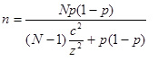
where:
n = minimum sample size
N = population size (number of HH in a village)
z = normal score, determined by the confidence level we desire; using 1.96 for a confidence level of 95%
c = margin of error (upper and lower bounds), the level of accuracy we would like to have
p = a rough estimate of the proportion of HH of our main interest in the survey
Table 2 shows the summary of the formula parameters used, and the sample size in each village.
Table 2 Sample size of each village
| Bagusa | Yoke | Karanganyar | Lebak | Hulu Pengkadan | Nanga Jemah | Sriwangi | |
| N | 57 | 54 | 686 | 397 | 191 | 201 | 133 |
| p | 0.7 | 0.8 | 0.5 | 0.5 | 0.5 | 0.5 | 0.5 |
| c | 0.1 | 0.1 | 0.1 | 0.1 | 0.1 | 0.1 | 0.1 |
| n | 34 | 28 | 84 | 78 | 64 | 65 | 56 |
Note that we used a larger proportion value (p) in Mamberamo Raya compared to Wonosobo and Kapuas Hulu since we considered Mamberamo Raya to have had less variation in terms of environmental situation and people behavior.
We used random sampling to select the households to be interviewed. In Mamberamo Raya we selected the respondents during village meetings, which most people attended. This helped us to: (1) make the activity fun and draw the attention of the villagers to the research with the hope that more would become involved in the project; and (2) avoid any jealousy among villagers, especially those not selected by the random selection. In Wonosobo and Kapuas Hulu, the selection was from a list of households provided by the heads of villages and according to the human population in the different dusun (subdivision of a village)for each village.
