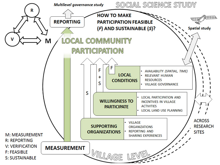
- PMRV
- Activities
- Social science
- Methods
Methods

Source: Boissière M., G. Beaudoin, C. Hofstee, S. Rafanoharana. 2014. Participating in REDD+ Measurement, Reporting, Verification (PMRV): opportunities for local people ? Forests (5): 1855-1878.
- Participatory mapping
Using base maps produced by the GIS team, the Social team worked with representatives from the villages to identify past and current land uses and land covers in the villages. The exercise was used to enrich the maps based on villagers’ knowledge of their territories.
- Household surveys
The household survey was designed to capture basic demographic information, household income sources, the type and frequency of forest interactions, village accessibility, current participation in village organizations and activities, and perceptions of natural resource availability over the last 10 years.
In total there were 161 households interviewed in Central Java (2 villages), 185 households in West Kalimantan (3 villages) and 63 households in Papua (2 villages). The sample size was calculated to be representative of the village population and households were chosen randomly.
- Key informant interviews
In-depth interviews were conducted with selected individuals (e.g. village head, elders, and customary or religious leaders) from each village to gather information on the following themes. When possible, gender balance was taken into account in selecting the interviewees. The interviews were structured around open-ended and close-ended questions.
- General information:
These interviews gathered information on the village history, changes in livelihoods, governance, boundaries, existing infrastructure and facilities, and future expectations for village development. - Experience mechanism:
These interviews gathered in-depth information about organizations relevant to PMRV. They consisted of a variety of question sets targeting group leaders, group participants and village leaders with knowledge of a variety of village organizations. The questions covered programs and other initiatives in the village that distribute resources, systems for information collection, sharing and reporting, resource distribution mechanisms, satisfaction with organizations and activities, and motivations for involvement in a particular organization or activity. - Land tenure:
These interviews gathered information on how the local community perceive and understand their land tenure arrangements, who the stakeholders of different areas of land are, the power relations both within and outside the village, and local perceptions of future land use and access. Basic land tenure maps used in the interviews were prepared by the GIS team to display land use and land cover polygons previously identified in the participatory mapping exercise.
- General information:
- Focus group discussions
In this method, several respondents (usually no less than 10 people) meet as a group to discuss a certain topic. We conducted the following focus group discussions (FDGs) in each village:
- Seasonal calendar:
Seasonal calendars were developed to gain an understanding of livelihood activities, the seasonality of the activities, workload variation (i.e. the busiest and less busy months/seasons) and the division of labor between women and men in the village. In each village, the discussion was held in two subgroups divided by gender. - Venn diagrams and sociograms:
The Venn diagram and sociogram activity was used to identify external and internal organizations and groups active in the village and related to the environment, particularly to PMRV activities. In the activity we mapped interactions and types of relationships (influence, dependency, cooperation and conflict) between organizations in terms of information flow, provision of services and decision-making. These discussions were conducted in two groups divided by gender (i.e. a women's group and a men's group) - Forest management:
The forest management FGDs looked at how people manage and rely on natural resources and what regulations exist at the village level to govern the use of these resources. There were three subgroups in these FGDs, which focused specifically on timber extraction, non-timber forest product harvesting and hunting. - Drivers of change:
The driver of change FGDs captured village perceptions of forest ecosystem services, their trends over time, their links with forest cover, drivers of forest change including deforestation, forest degradation and forest recovery, and possible incentives to address deforestation and forest degradation.
- Seasonal calendar:


