
- PMRV
- Multimedia
- Maps
Maps
In each of the seven PMRV project research villages we created a series of maps including remote sensing land cover analysis, participatory land cover map and participatory land use map. The participatory maps were created in a focus group activity with key informants from each village. In creating land cover maps through both participatory and remote sensing methods we aim to identify potential synergies between the two methods that can be incorporated into PMRV. The three map types are used to better understand and measure forest cover change in each site. The maps are further enriched by the social science research team¹s analysis on drivers of forest cover change, forest management practices, and land tenure arrangements. Below is a selection of maps from one village in each research site (Papua, Java, and Kalimantan).
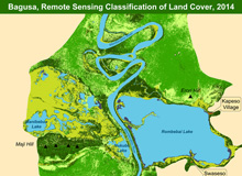
Remote sensing land cover map for Bagusa, Papua
The land cover map for Bagusa Village in Papua was derived from the 2005 Landsat TM. A supervised classification technique was used based on the maximum likelihood estimation. Seven classes were identified including different levels of vegetation density and vegetation types such as swampy bush and marsh, settlement, and water body. The presence of cloud and haze in the images was a major problem and had to be removed. The social research team conducted a ground check to collect additional GPS points. This was to help improve the classification results, however, it was limited due to the difficulty in accessing some areas and time constraints.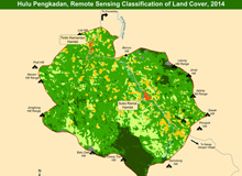
Remote sensing land cover map for Hulu Pengkadan, West Kalimantan
The land cover map for Hulu Pengkadan Village in West Kalimantan was derived from SPOT 5 data for year 2011. A supervised classification technique, based on the maximum likelihood estimation, was also applied. Six land cover classes were identified including different levels of vegetation density, settlement, and water body. Ground truthing data was collected through an extensive field survey conducted by the remote sensing/GIS team to contextualize the classification results.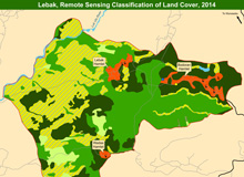
Remote sensing land cover map for Lebak, Central Java
A 2012 Google Earth Pro image was used to identify the different types of land cover in Lebak Village in Central Java. Polygons and lines were produced and identified based on visual interpretation. Ground checks were conducted to identify important key features and to improve the classification results.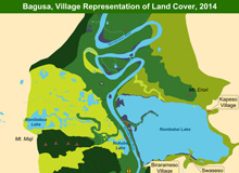
Participatory land cover map for Bagusa, Papua
Village volunteers created participatory maps of land cover for their villages, identifying the different land covers and their vegetation types. After the first draft of the map, a ground check was necessary to geo-reference the main features (rivers, villages, roads etc.,). The maps were digitized using GIS software and verified by the villagers. This map displays the Papuan villagers' ecologically based classifications of land cover in their territory.Participatory land cover map for Hulu Pengkadan, West Kalimantan
Village volunteers created participatory maps of land cover for their villages, identifying the different land covers and their vegetation types. After the first draft of the map a ground check was necessary to geo-reference the main features (rivers, villages and roads etc.,). The maps were digitized using GIS software and verified by the villagers. The land covers represent the current land cover of lands dedicated to rotating agriculture. A typical agricultural rotation begins with the forest being converted to dry rice fields. The rotation cycle includes a 3-year period of dry rice cultivation, resting and a regrowth period (fallow), or a 25-year period of rubber cultivation. Other cultivated lands, in addition to the area for rotating agriculture, include: wet rice fields and agroforests with tengkawang (Borneo tallow nut from the genus Shorea) and/or durian (genus Durio) being the predominant species.Participatory land use map for Hulu Pengkadan, West Kalimantan
Once the participatory map of land cover had been completed, village volunteers drew the different land uses on the map. The spatial representations provide an approximation of where villagers undertake such activities. The agricultural and agroforestry land use area is a direct reflection of the land cover. Land uses within primary and secondary forest include hunting and gathering non-timber forest products, such as rattan, and wild fruits and vegetables. Other activities, such as gathering timber or collecting durian and tengkawang, follow the river tributaries because of the ease and history of access and riparian ecosystem characteristics. Another land use is fallow where the land is intentionally being left to rest before being converted back to dry-rice and vegetable cultivation. In addition to the spatial data, social surveys deepen the understanding of this spatial land use and help further the comprehension of land cover dynamics.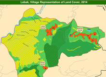
Participatory land cover map for Lebak, Central Java
Village volunteers created participatory maps of land cover for their villages, identifying the different land covers and their vegetation types. After the first draft of the map a ground check was conducted to geo-reference the main features (rivers, villages, and roads etc.,). The maps were digitized using GIS software and verified by the villagers. This example from Central Java illustrates that the various land covers in the area are predominantly anthropogenic such as Perhutani pine plantations, agroforestry and agricultural lands, and settlements.